
The River Dart
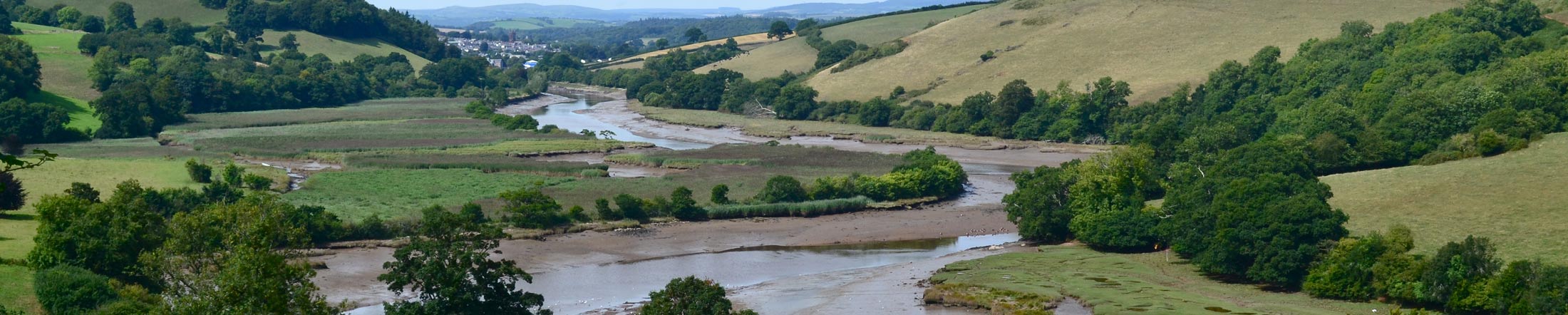
The River Dart arises 550 metres above sea level on the high mires of north Dartmoor at its most distant (52 miles) and flows to the sea passing through Dartmeet, Buckfastleigh and Totnes, then Dartmouth and Kingswear on either side of the estuary mouth.
The Dart Estuary
The estuary is the tidal extent of the River Dart where the freshwaters of the river catchment meet and mix with the tidal saltwater of the coast. The Dart Estuary is tidal up as far as the Totnes Weir, just upstream of the estuary’s first bridging point 12 miles from the mouth.
Like most South West estuaries, the River Dart estuary is a drowned river valley or ria type estuary. The original deep-carved river valley was formed through the ice age and then believed to meet the coast just east of Start Point; the post glacial sea level rise (c.120m) drowned and inundated the river valley with the characteristic steep sided and deep waters of a ria – lending itself as a useful harbour to become Dart Harbour.
The River Dart has a relatively large water catchment to the size of the estuary and is a typically freshwater dominated, particularly during heavy rain periods.
Designations
Most of the Dart Estuary lies within the South Devon National Landscape and South Devon Heritage Coast.
The Upper Dart Estuary (from tidal limit to the Anchor Stone) was designated as a Marine Conservation Zone in 2019 – www.gov.uk/government/publications/marine-conservation-zones-dart-estuary celebrating the area’s special value, features and wildlife.
The Lyme Bay & Torbay Special Area of Conservation also extends just inside the mouth of the Dart Estuary.
Wildlife
Estuaries, with their continually changing salinities and tidal exposures, typically support lower diversities of wildlife species but those species that can tolerate these conditions may often be supported in very high population numbers. The Dart Estuary is no exception and supports rich populations of birds, fish, crabs, shellfish, seals, otters and the occasional dolphin and porpoise.
The relatively calm conditions of estuaries naturally trap a lot of organic debris, silt, etc., some from the tides but certainly in the case of the Dart, predominantly from its water catchment area. This supports highly productive habitat communities of saltmarsh, tidal reedbeds and mudflats, that are increasingly important globally for the carbon that they trap, sequester and store for geological timescales if left undisturbed.
The Dart estuary supports a wide variety of wildlife including birds, fish, crabs, shellfish, grey seals, otters and the occasional dolphin. Not to mention the extremely important worms, snails and bacteria on which many other species depend.
Caring for the estuary
The Dart estuary sits in a steep-sided river valley with a large catchment area making it very vulnerable to pollution. The Dart estuary is affected by both point source pollution (has a traceable source into the estuary) and diffuse pollution (comes from the land or atmosphere).
Pollutants can be highly toxic killing wildlife within the Dart. They can also reduce the oxygen content and water quality of the estuary potentially leading to ‘anoxic dead zones’. It is important that we understand how our actions can affect the estuary and what we can do to prevent them.
- Dispose of all waste carefully, recycling as much as possible.
- Try using low phosphate, environmentally degradable cleaning products.
- When changing oil and refuelling cars be careful not to spill any, as it will end up in the estuary downstream.
Further information regarding this issue and additional preventative actions are available to view on the dedicated Dart Estuary Pollution page of our website.
Blue carbon
Our coast and estuaries play an important role in the binding of the world’s biological carbon (or green carbon), with more than half being captured by marine living organisms (hence it is called blue carbon).
With such an important carbon fixing resource on our doorstep, it is important that we restore and maintain healthy marine ecosystems. For further details please read the full blue carbon report.
Getting around
- On foot: The Dart Valley Trail is a great way to explore the estuary. A leaflet is available for sale from Tourist Information Centres.
- By river cruiser: River boats run between Totnes and Dartmouth, between Dartmouth town and Dartmouth castle, and between Dartmouth and Greenway.
- Ferry crossings: Both passenger and vehicle ferries operate year-round services crossing between Dartmouth and Kingswear. There is a small passenger ferry crossing between Dittisham and Greenway.
Estuary conservation and management
An estuaries management plan for all five South Devon estuaries has been published covering the eight year period 2016-2024 and is available to download at the top right of this page.